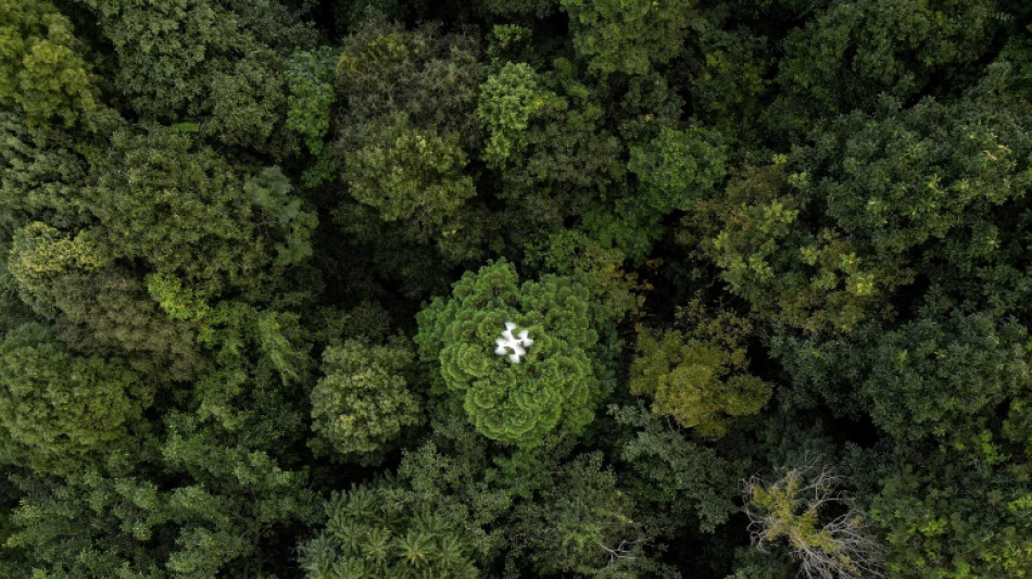
Drones help solve forest carbon capture riddle / Photo: MANAN VATSYAYANA - AFP
 Australia ask for more information on FIFA sell-off plan
 South Korean stocks bounce after rout, oil holds gains on Mideast woes

 Stokes should return for 'one more Ashes': Australia coach McDonald

 Ngumoha scores as Liverpool beat Wrexham 1-0 in New York friendly

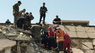
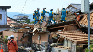 Up to 23 feared dead in Japan quake
 Samsung operating profit up 1,800% in second quarter on AI boom

 De Zerbi wants Bergvall at Spurs, but can't promise starting role

 De Minaur tops Tsitsipas to set up Hewitt clash in Washington

 Japanese population below 120 million for first time in decades
 Meta misses profit expectations, sticks to massive AI spending

 Inequality best predicts how nations handle pandemics: study

 Brazil's Jair Bolsonaro denies authorizing deepfake for election message
 Boaduwaa strikes as Ghana beat WAFCON debutants Cape Verde

 US actor Jared Leto denies latest accusations of sexual assault

 Danube drops to 'historic lows' as fresh heatwave hits

 US Federal Reserve holds rates steady as inflation hawks call for hike

 Eala beats defending champ Fernandez in Washington
 US man accused of destroying evidence by wiping phone at airport

 BTS pulls out of Grammys after Asian pop category introduction

 Judge orders Amy Winehouse's father to pay nearly £1mn to her friends
 Crisis-hit Cuba opens pharmacies, gas stations to private firms

 Pro-Kremlin TV commentator ordered to leave France, under house arrest

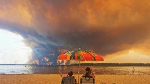
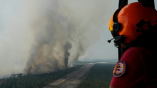
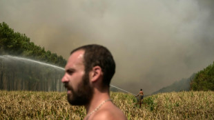 'I started crying': Battle to tame fresh blaze near French seaside

 Former top US Covid expert Fauci declines to answer hostile Senate questioning

 Neymar says his time playing for Brazil 'is over'
On a hillside overlooking cabbage fields outside the northern Thai city of Chiang Mai, a drone's rotors begin to whir, lifting it over a patch of forest.
It moves back and forth atop the rich canopy, transmitting photos to be knitted into a 3D model that reveals the woodland's health and helps estimate how much carbon it can absorb.
Drones are part of an increasingly sophisticated arsenal used by scientists to understand forests and their role in the battle against climate change.
The basic premise is simple: woodlands suck in and store carbon dioxide, the greenhouse gas that is the largest contributor to climate change.
But how much they absorb is a complicated question.
A forest's size is a key part of the answer -- and deforestation has caused tree cover to fall 12 percent globally since 2000, according to Global Forest Watch.
But composition is also important: different species sequester carbon differently, and trees' age and size matter, too.
Knowing how much carbon forests store is crucial to understanding how quickly the world needs to cut emissions, and most current estimates mix high-level imagery from satellites with small, labour-intensive ground surveys.
"Normally, we would go into this forest, we would put in the pole, we would have our piece of string, five metres long. We would walk around in a circle, we would measure all the trees in a circle," explained Stephen Elliott, research director at Chiang Mai University's Forest Restoration Research Unit (FORRU).
But "if you've got 20 students stomping around with tape measures and poles... you're going to trash the understory," he said, referring to the layer of vegetation between the forest floor and the canopy.
That is where the drone comes in, he said, gesturing to the Phantom model hovering overhead.
"With this, you don't set foot in the forest."
- 'Every tree' -
Three measurements are needed to estimate a tree's absorptive capacity: height, girth and wood density, which differs by species.
As an assistant looks through binoculars for birds that might collide with the drone, the machine flies a path plotted into a computer programme.
"We collect data or capture (images) every three seconds," explained Worayut Takaew, a FORRU field research officer and drone operator.
"The overlapping images are then rendered into a 3D model that can be viewed from different angles."
The patch of woodland being surveyed is part of a decades-long project led by Elliott and his team that has reforested around 100 hectares by planting a handful of key species.
Their goal was not large-scale reforestation, but developing best practices: planting native species, encouraging the return of animals that bring in seeds from other species and working with local communities.
The drone's 3D model is a potent visual representation of their success, particularly compared to straggly untouched control plots nearby.
But it is also being developed as a way to avoid labour-intensive ground surveys.
"Once you've got the model, you can measure the height of every tree in the model. Not samples, every tree," said Elliott.
A forest's carbon potential goes beyond its trees, though, with leaf litter and soil also serving as stores.
So these too are collected for analysis, which Elliott says shows their reforested plots store carbon at levels close to undamaged woodland nearby.
- 'More and more precise' -
But for all its bird's-eye insights, the drone has one major limitation: it cannot see below the canopy.
For that, researchers need technology like LiDAR -- high-resolution, remote-sensing equipment that effectively scans the whole forest.
"You can go inside the forest... and really reconstruct the shape and the size of each tree," explained Emmanuel Paradis, a researcher at France's National Research Institute for Sustainable Development.
He is leading a multi-year project to build the most accurate analysis yet of how much carbon Thailand's forests can store.
It will survey five different types of forests, including some of FORRU's plots, using drone-mounted LiDAR and advanced analysis of the microbes and fungi in soil that sustain trees.
"The aim is to estimate at the country level... how much carbon can be stored by one hectare anywhere in Thailand," he said.
The stakes are high at a time of fierce debate about whether existing estimates of the world's forest carbon capacity are right.
"Many people, and I'm a bit of this opinion, think that these estimates are not accurate enough," Paradis said.
"Estimations which are too optimistic can give too much hope and too much optimism on the possibilities of forests to store carbon," he warned.
The urgency of the question is driving fast developments, including the launch next year of the European Space Agency's Biomass satellite, designed to monitor forest carbon stocks.
"The technology is evolving, the satellites are more and more precise... and the statistical technologies are more and more precise," said Paradis.
D.Kaufman--AMWN